
🎶 Southern Oregon’s legendary Rogue Suspects are bringing the groove to the Yreka Summer Concert Series this Friday, July 18! 🎸🌟
Join us at the park for a night of classic, high-energy jams you won’t want to miss. Bring your lawn chairs, your dancing shoes, and your summer vibes! ☀️🕺💃
🎤 Music starts at 6:30 PM
📍 Miner Street Park, Yreka
🎟️ Free & family-friendly!
🌮 Food + Beverage Trucks On-Site
#YrekaSummerConcerts #RogueSuspects #LiveMusicYreka #SiskiyouVibes #discoversiskiyou #seesiskiyou #redding #mtshasta #yreka #southernoregon #medford #ashland #norcal

🚗✨ Etna, CA: where charm meets adventure in the heart of the Siskiyous. From artisan butcher shops to mountain trails and locally brewed beers, this little town packs a big punch. 🌄🍻
What`s your favorite spot in Etna?
#SmallTownExpeditions #EtnaCalifornia #DiscoverSiskiyou #HiddenGems #RoadTripVibes #siskiyou #etna #siskiyoucounty #smalltowns #norcal #mountaintowns
🎶 Get ready, Yreka! Sacramento’s funk and soul powerhouse The Gold Souls are bringing the groove to Summer Concerts in the Park this Friday, July 11! 💃🕺 Grab your blankets, your friends, and your dancing shoes—music kicks off at 6:30 PM at Miner St. Park! 🎤🎷✨
#YrekaSummerConcerts #TheGoldSouls #LiveMusicYreka #yreka #siskiyou #siskiyoucounty #redding #ashlandoregon
🌲✨ Tucked away in the heart of the Klamath National Forest, Happy Camp is your gateway to wild beauty, outdoor adventure, and small-town charm. Whether you`re casting a line in the Klamath River, hiking through ancient forests, or just soaking in the quiet, there`s something peaceful—and powerful—about this special corner of West Siskiyou.
🚗 Take the scenic drive and discover why it`s called Happy Camp.
#DiscoverSiskiyou #HappyCampCA #VisitCalifornia #NorCalHiddenGems #KlamathRiver #AdventureAwaits
Happy Fourth of July! 🎆
Whether you’re chasing waterfalls, hiking under the stars, kayaking on crystal-clear lakes, or enjoying a local festival—Siskiyou is the perfect place to make holiday memories.
🎇 Please remember to recreate responsibly - do not light your own fireworks, and pack out all of your trash! Tag us in your weekend fun using #DiscoverSiskiyou and stay safe out there! 🗻🌲💥
📸: @livelikeitsthewknd
#discoversiskiyou #seesiskiiyou #visitcalifornia #norcal #california #adventure #pnw #chasingwaterfalls #granolagirls #mtshasta
Summer’s heating up in Siskiyou — don’t miss a July packed with festivals, music, and mountain adventure! ⛰🎶✨Click the "Events" link in our bio for all the details!
🇺🇸 Mt. Shasta Fourth of July Celebration + Fun Run
📅 July 3-5 | 📍Downtown Mt.Shasta
🎆 Montague Fourth of July Freedom Festival
📅 July 3-5 | 📍Hoag Park, Montague
🏃🏽♀️ Dirty Dash 1.5 + 5k Races
📅 July 5 | 📍Kidder Creek Camp, Etna
🎡 Weed Carnevale
📅 July 10-12 | 📍Bel Air Park, Weed
🎸 Yreka Summer Concerts in the Park
📅 July 11 + 18 | 📍Miner Street Park, Yreka
🎶 Mt. Shasta Concert Series
📅 July 13, 20 & 27 | 📍Shastice Park, Mount Shasta
🪓 Lumberjack Fiesta
📅 July 25-27 | 📍Hoo Hoo Park, Mcloud
🤠 47th Annual Old Timer`s Rodeo
📅 July 26 | 📍Scott Valley Pleasure Park, Etna
#discoversiskiyou #seesiskiyou #summerfestival #livemusic #redding #norcal #mtshasta #yreka #scottvalley
Who are you sending this to 👀 #discoversiskiyou #seesiskiyou #waterfall #waterfallwednesday #norcal #california #visitcalifornia
🌟Yreka Golden City Days 2025🌟
Celebrating Yreka’s rich history, community, and small-town charm on historic Miner Street 🪕🍗🍻☀️🤠
From live music and mouthwatering barbecue to historic tours and a Father’s Day car show — this is where memories are made. 💛
#GoldenCityDays #Yreka #SmallTownStrong #SiskiyouSummer #discoversiskiyou #siskiyou #norcal #smalltown
Summer event season is here! Swipe through for a selection of upcoming events, and view our full events calendar at www.discoversiskiyou.com/events for more details!
🌸 An Evening at the Farm
📅 June 3 | ⏰ 5:30-8PM | 📍 California Peony Company, Callahan
🚂 Dunsmuir Railroad Days
📅 June 13-15 | ⏰ 9 AM-4PM | 📍 Downtown Dunsmuir
⛏ Golden City Days
📅 June 14-15 | ⏰ Sat 2-8PM, Sun 11AM-5PM | 📍 Downtown Yreka
🚙 Father`s Day Car Show + Chili Cook Off
📅 June 15 | ⏰ 9AM-2:30PM | 📍 Miner Street Park, Yreka
🎬 Glow Fest
📅 June 19-22 | ⏰ 12-8PM | 📍 The Rec, Fort Jones
🏳️🌈 Siskiyou Pride 2025
📅 June 21 | ⏰ 12-6PM | 📍 Mt. Shasta Brewing Co., Weed
🍷 Shasta Mountain Art, Wine & Brew Fest
📅 June 21 | ⏰ 2-6PM | 📍 Shastice Park, Mt. Shasta
🪕 Trails End Music Festival
📅 June 27-28 | ⏰ Fri 6-10:30PM Sat 10AM-10:30PM | 📍 Main Street, Etna
#discoversiskiyou #seesiskiyou #norcal #upstateca #visitca #pnw #shasta #mtshasta #redding #events #mtb #yreka #etna #musicfest
🌸✨ Save the Date: June 3 | 5:30–8PM ✨🌸
Join @californiapeonycompany @dennybarcompany and @etna.brewing for an evening under the stars at the stunning California Peony Co. Farm in Callahan (West Siskiyou).
Celebrate all things local with:
🍹 Signature cocktails + small-batch brews
🍽️ Elevated bites & artisenal treats
🎶 Live music
🎯 Lawn games
🌼 Fresh blooms & good vibes
Mingle with local makers, sip, snack, and soak in the beauty of Northern California in full bloom. You won’t want to miss this magical night on the farm!
Get your tickets at https://www.californiapeonycompany.com/
#peonies #norcal #visitcalifornia #siskiyou #redding #shasta #california #farmdinner #farmtours #farmvisit #onthefarm
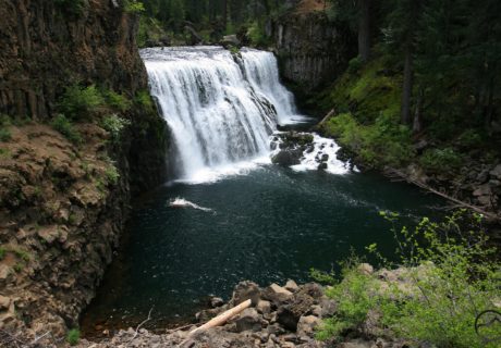
🌊 McCloud Upper Falls 💙
Quick stop, BIG views.
Easy trail, epic water flow, and that fresh mountain air 🌲⛰️
If you want to see Siskiyou`s waterfalls at their peak, now is the time!
📸: @heidy_dianeth
📍 McCloud, CA
💦 Part of the 3 McCloud River Falls
🌲 Perfect for a peaceful escape
#McCloudFalls #discoversiskiyou #NorCalHikes #WaterfallVibes #MtShasta #norcal #HikingCalifornia
Hedge Creek Falls in Dunsmuir = pure magic! 💧💙
This hidden gem is a short, easy hike with a big reward — a stunning waterfall you can actually walk behind! 🌲🌊
📸: @may_hz7
📍 Location: Just off I-5 near Dunsmuir
🥾 Trail: Super easy, family-friendly
#siskiyou #siskiyoucounty #norcal #discoversiskiyou #HedgeCreekFalls #WaterfallWanderlust #NorCalNature #HiddenGems
🌲✨ Accessible adventures await in Siskiyou! From wheelchair-friendly trails to scenic drives with epic views, there`s something for everyone to explore. Nature should be for all — and in Siskiyou, it truly is. ♿❤️
Click the link in our bio for accessible Siskiyou adventures.
📸: @wheelchairtraveling
#AccessibleAdventures #DiscoverSiskiyou #NatureForAll #WanderWithoutLimits
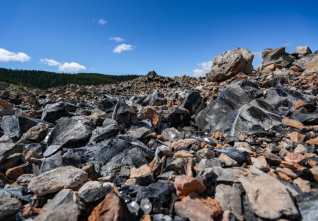
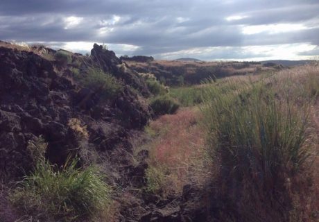
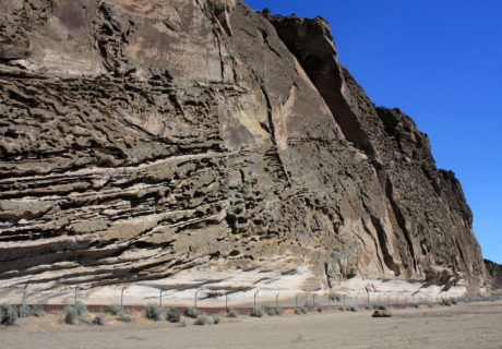
🌋✨ Exploring @lavabedsnps is like stepping onto another planet! From epic lava tube caves to ancient petroglyphs, every corner tells a story millions of years in the making. 🖖🏞️
If you’re craving adventure and a place that’s totally off the beaten path, this is it. Bring a flashlight, good shoes, and a spirit for exploration! 🥾🗺️
#LavaBeds #SiskiyouAdventures #NatureIsMagic #ExploreCalifornia #CaveExploring #seesiskiyou #discoversiskiyou #visitcalifornia #california #caves #geology #norcal
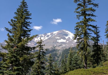
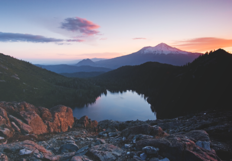
Chasing light, finding peace. 🌄✨
Mt. Shasta glowing in the golden hour—nature really showing off.
📸: @happylustig
#MtShasta #SunsetVibes #NatureHeals #WanderMore #discoversiskiyou #seesiskiyou #california #norcal


